


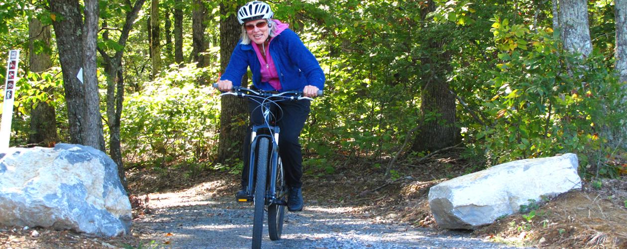
Biking in LBL
A cyclist enjoys a trip down the Central Hardwoods Trail in LBL.


![]() > LBL
> Cycling
> LBL
> Cycling
Cycling and Mountain Biking in LBL
The bike trails that wind their ways through the natural terrain, woodlands and open spaces of the Land Between the Lakes National Recreation Area are a dream come true for those individuals who enjoy a scenic trek on a road bike or a mountain bike adventure.
The area has no shortage of delicious landscapes on which to feast one's eyes during a leisurely ride, as well as rugged terrain suited for both beginner and advanced mountain bike lovers.
There are over 500 miles of trails and 200 miles of scenic roadways for cyclists and hikers to enjoy during a visit to this national recreation area. While some trails are limited to hiking only, there are several bike trails with a variety of excursions for cyclists and mountain bike riders to explore.
Here is what you might expect to find at five of the region's best bike trails.
North/South Trail – Cycling and Mountain Biking
The northern leg of the North/South (N/S) Trail stretches 31 miles across the Land Between the Lakes. This part of the trail is open to cyclists. By the time you reach the Golden Pond Visitor Center the trail becomes a hiking trail only from there to the south. Be sure to review trail maps in order to map out an appropriate course for your rides.
The N/S trail is comprised of mostly single track trails which weave through heavily wooded ridges and offer shoreline views of the lakes. There are seven springs found along this northern portion of the trail and three backcountry shelters that work well for those who want to camp overnight. The trail connects to the Nature Station where you can find water and other trail maps.
Trail Map - North Leg of N/S Trail
Canal Loop Bike Trail – Cycling and Mountain Biking
The canal loop is a favored spot of cyclists and mountain biking enthusiasts. In fact, it's considered Land Between the Lakes' premier mountain biking trail.
This 11-mile, single-track loop includes three connectors which provide trail routes ranging from 1.5-miles to 11 miles. It offers stellar views of the lakes, as well as some challenging excursions for mountain bikers who wish to take a few detours along the way. The trail offers views overlooking Kentucky Lake, Lake Barkley and the canal. It's a moderate to difficult bike trail.
Trail Map - Canal Loop Bike Trail
Central Hardwoods Bike Trail – Cycling and Mountain Biking
This is an easy to moderate bike trail. It's the perfect spot for those new to mountain biking and cycling. This family-friendly route includes smooth surfaces, gentle grades and a few trailside rest areas along the route. The trail runs parallel to U.S. 68/KY 80.
The eastern portion of the path is paved and offers cyclists a picture-perfect view of Lake Barkley and covers about 2.5 miles of terrain. The 8.5-mile trail that runs through the central and western parts of the path is composed of a compacted stone surface, which also allows for a smooth ride for cyclists of all skill levels.
Throughout the Central Hardwoods Bike Trail cyclists have plenty of rolling hills and ridgetops to take in, making it a peaceful ride throughout. This trail connects to the hike/bike path across Eggners Ferry Bridge at Kentucky Lake.
Trail Map - Central Hardwoods Bike Trail
Fort Henry Bike Trail – Cycling
The south end of Land Between the Lakes is home to The Fort Henry Trails. These nine trails are open to cyclists and cover 26 miles. They follow the course taken by General Grant and his Union troops as they made their way from Fort Henry to Fort Donelson during the Civil War.
Springs are unreliable on this trail, therefore cyclists should bring their own water for the ride. Trails winding through this historic landscape range from easy to moderate and give cyclists stunning views of woodlands, hollows, creeks, seasonal springs and beaver dams. Those seeking a bit more history will enjoy a trek down the Telegraph Trail which includes the remains of a few historic home sites and cemeteries.
Trail Map - Fort Henry Trial System
Hillman Heritage Bike Trail – Cycling
Those seeking to ride the Hillman Heritage Bike Trail will need to check in and register at Hillman Ferry Gatehouse before hopping on the trails here. Located within the Hillman Ferry Campground, this 5.47-mile bike trail winds through the historic roads once utilized by the former Star Lime Works community, which disbanded upon the creation of Kentucky Lake after 1945.
These trails are open to campers staying at Hillman Ferry Campground and the general public. They are easy to moderate trails, making it a comfortable ride for most cyclists.
Trail Map - Hillman Heritage Bike Trail
Tips for Cyclists and Mountain Bikers at Land Between the Lakes
- Trail maps are available on our Land Between The Lakes maps page.
- Cyclists share the road with hikers on these trails so be cautious while riding these scenic byways.
- You'll want to check the website for Land Between the Lakes' trail alerts and notices before planning your cycling trip.
- You'll want to pack in plenty of water for your ride. Along some of the bike trails, there are a few seasonal springs from which cyclists can draw water and filter through their own water filters. However, there are no water stations located along these bike trails.
Looking for a Place to Camp?
With so many trails from which to choose you are certain to find something that is well-suited for your skill level and interests. If you're planning an extended cycling trip you might check out the backcountry camp sites and other campgrounds located throughout Land Between the Lakes.
Need A Place to Stay Near Land Between The Lakes?
You might need a place to crash for the night (no pun intended!) when planning a biking trip to Land Between The Lakes. There are plenty of places to stay right outside the national recreation area.