
BOAT
BOAT
Kentucky Lake
& Lake Barkley

Nav Charts & Markers
Planning to explore Kentucky Lake or Lake Barkley by boat? A good set of navigation charts can help you get familiar with the waterways before heading out. Below you’ll find official charts published by the U.S. Army Corps of Engineers, available as downloadable PDFs. They’re a handy resource for navigating the lakes, especially if you’re venturing into unfamiliar waters.
Tennessee River
Below Kentucky Dam
Kentucky Lake
- 4 – Kentucky Dam & Grand Rivers
- 4A – Barkley Canal and LBL
- 5 – Little Bear Creek
- 6 – Duncan & Sugar Bay
- 7 – Kenlake State Park
- 8 – Reed Hollow & Snipe Creek
- 89 – Jonathan Creek
- 9 – Ginger & Clay Bay
- 90 – Blood River
- 10 – Hughes & Panther Bay
- 91 – Big Sandy River
- 92 – West Sandy Creek
- 11 – Paris Landing State Park
- 12 – Robbins & Short Creek
- 13 – Hurricane Creek & Bass Bay
- 14 – Whiteoak Creek & Turkey Creek
- 15 – Richland Creek & Harmon Creek
- 16 – Trace Creek & Beaver Dam Creek
- 17 – New Johnsonville & Birdsong
- 18 – Eagle Creek
- 93 – Duck River (downstream)
- 94 – Duck River (upstream)
- 19 – Cuba Landing & Interstate 40
Cumberland River
Below Barkley Dam
Lake Barkley
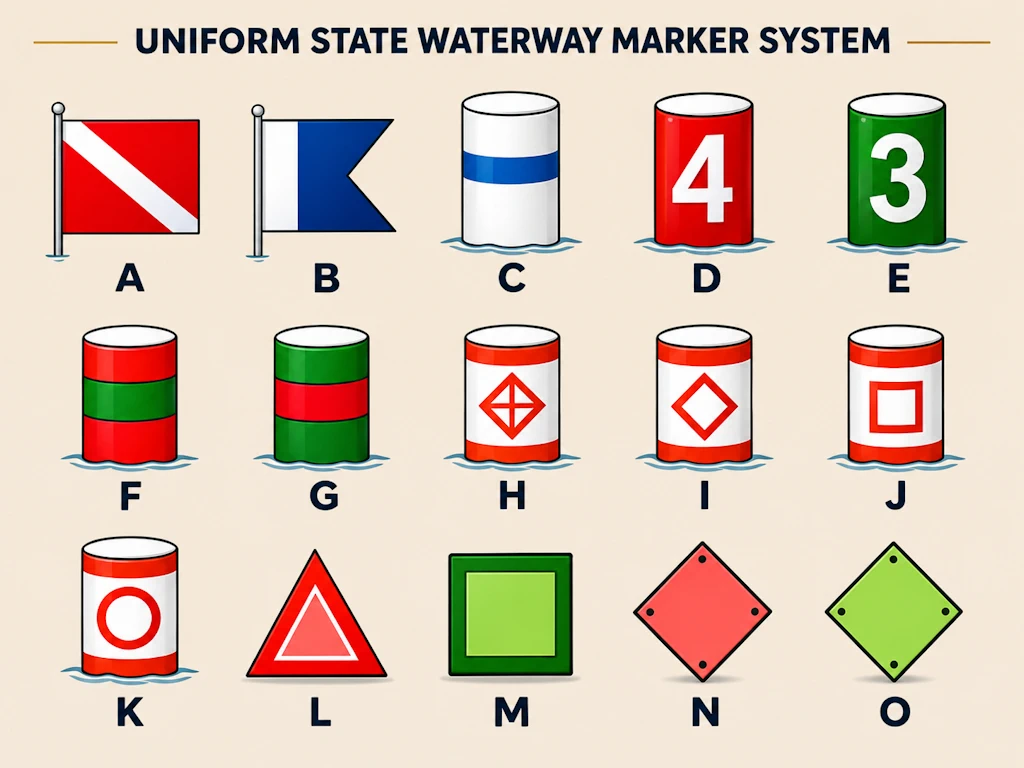
Navigation markers chart.
Those colorful buoys and signs scattered around Kentucky Lake and Lake Barkley aren’t just decorations. They’re there to help boaters stay in navigable channels, recognize hazards and understand restrictions on the water. Some are pretty straightforward, while others take a little getting used to.
Both lakes use the standard U.S. waterway marking system, which relies on colors, shapes, numbers and symbols to communicate important information. Before heading out, especially if you’re new to boating on these lakes, it’s worth getting familiar with what these markers mean.
Use the diagram above to identify the different types of markers, then check out the explanations below.
Diving Flags
A. Diver’s Flag
A red flag with a white diagonal stripe means divers are in the water. Give them plenty of room! In Kentucky, boats must stay at least 100 feet away from a displayed diver-down flag. In Tennessee, boats must stay at least 50 feet away and operate at a slow, no-wake speed within 200 feet.
B. Alpha Flag
The blue-and-white Alpha flag indicates that a vessel is engaged in diving operations and may have limited ability to maneuver. Boaters should proceed with extreme caution and watch for nearby divers.
Channel Markers & Mooring Buoys
C. Mooring Buoy
A white buoy with a horizontal blue stripe identifies a designated mooring location. These are the buoys intended for securing boats. Never tie your boat to navigation markers or regulatory buoys.
D. Red Channel Marker
Red markers identify the right side of a navigable channel when traveling upstream. Keep these markers on your right as you head upstream and on your left when traveling downstream.
An easy way to remember it: red on the right when heading upstream.
E. Green Channel Marker
Green markers identify the left side of a navigable channel when traveling upstream. Keep these markers on your left when heading upstream and on your right when traveling downstream.
F. Red-Over-Green Junction Buoy
These striped buoys indicate a junction where channels meet or separate. When traveling upstream, a red-over-green marker indicates that the preferred channel is to your left as you pass the buoy on your right.
G. Green-Over-Red Junction Buoy
Similar to the red-over-green marker, this buoy identifies a channel junction. When traveling upstream, a green-over-red marker indicates that the preferred channel is to your right as you pass the buoy on your left.
Regulatory & Information Buoys
H. Boats Keep Out Buoy
A white buoy with orange bands and a crossed diamond means exactly what it sounds like: boats aren’t allowed beyond the marked boundary. You’ll commonly find these near swimming areas, dams and other restricted locations.
I. Danger Buoy
A white buoy displaying an orange diamond warns boaters of potential hazards. These might include submerged obstructions, rocks, cables or other dangerous conditions. Slow down, pay attention and give the area plenty of room.
J. Information Buoy
A white buoy with an orange square provides helpful information for boaters. These markers may display directions, distances, place names, marina information or other useful details.
K. Control Buoy
A white buoy displaying an orange circle indicates an operating restriction. Look for posted instructions such as “No Wake,” speed limits, no skiing or no fishing. The restriction shown on the marker tells you what applies in that area.
Daymarks & Channel Crossings
Unlike floating buoys, daymarks are fixed signs mounted on poles, structures or along the shoreline. They serve many of the same navigation purposes as channel markers.
L. Red Passing Daymark
A red triangular daymark identifies the right side of the channel when traveling upstream. Like a red channel buoy, it should be kept on your right as you head upstream.
M. Green Passing Daymark
A green square daymark identifies the left side of the channel when traveling upstream. Keep it on your left as you head upstream.
N. Red Channel Crossing Daymark
A red diamond-shaped daymark indicates that the navigable channel crosses from the right side of the river toward the left as you travel upstream. These markers help guide boaters through changes in the channel’s path.
O. Green Channel Crossing Daymark
A green diamond-shaped daymark indicates that the navigable channel crosses from the left side of the river toward the right when traveling upstream.
A Few Things to Remember
Kentucky Lake and Lake Barkley are part of the Tennessee and Cumberland river systems, so understanding upstream and downstream navigation is especially important.
Remember that when traveling upstream, red channel markers are generally kept on your right and green markers on your left. Also, don’t assume that the water outside a marked channel is deep enough for your boat. Depths can change considerably, especially when lake levels are lower.
Navigation markers are there to help, but they don’t replace a good set of charts, current lake information and a little common sense. Pay attention to the weather, watch for commercial traffic and take your time when exploring unfamiliar areas.
Official Navigation & Boating Resources
For more information about boating regulations and waterway markers, visit the Tennessee Wildlife Resources Agency, Kentucky Department of Fish & Wildlife Resources or consult the U.S. Coast Guard’s Aids to Navigation System.
This information is provided as a general boating reference. Always follow current navigation markers, official charts, posted restrictions and applicable state and federal boating regulations.